Mississippi County Safety Action Plan
On June 24, 2025, Mississippi County adopted their Safety Action Plan developed under the USDOT SS4A Program. The Plan was developed based on the requirements established by the USDOT for SS4A Safety Action Plans. The Mississippi County Safety Action Plan consisted of the following seven SS4A safety action plan components:
1. Leadership Commitment and Goal Setting
2. Planning Structure
3. Safety Analysis
4. Engagement and Collaboration
5. Policy and Process Change
6. Strategy and Project Selections
7. Progress and Transparency
Each of these components can be found within the final adopted plan.
CLICK HERE TO VIEW FINAL ADOPTED PLAN
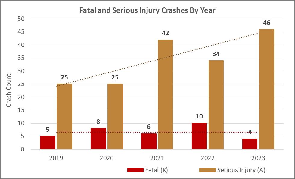
Goal Setting: As a part of the plan development, Mississippi County established a goal of attaining a 50% reduction in fatal and serious injury crashes by 2035 and a long-term goal of eliminating fatal and serious crashes on the network by 2050. Below is a chart showing the past 5 years of fatal and serious injury crash data in Mississippi County.
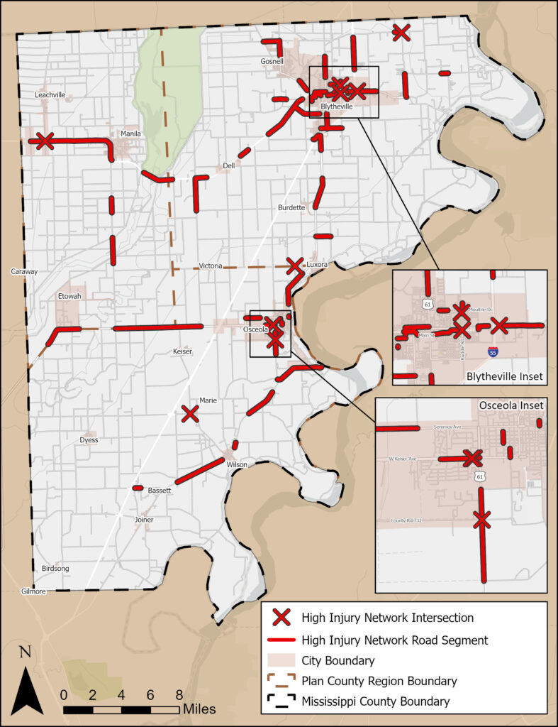
Safety Analysis: A component of a Safety Action Plan is developing a High Injury Network (HIN). The HIN contains the roadway segments and intersections which have the highest concentration of fatal and serious injury crashes. For the Mississippi County Safety Action Plan, the Countywide HIN consisted of the segments and intersections with high frequencies of these fatal and serious injury crashes, as shown in the map below.
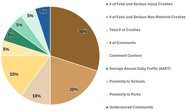
Prioritization: A prioritization process was performed to determine the Mississippi County HIN road segments and intersections that exhibit the greatest need for safety countermeasures. A description of the prioritization process can be found in the full report. The prioritization criteria used in the process are:
Crash Data
Number of Fatal and Serious Injury Crashes
Number of Non-Motorist Crashes
Total Number of Crashes
Stakeholder & Public Input
Number of Comments
Comment Content
Location
Average Annual Daily Traffic (AADT)
Proximity to Schools
Proximity to Parks
Census Tract Data
Underserved Community
Project Recommendations: At the beginning of the Safety Action Plan’s development, Mississippi County staff expressed concern regarding the Safety Action Plan including representation from across the County due to most of the County’s population residing or working in Osceola and Blytheville. The project team worked with the County staff to divide the County into three equally sized regions, using major roadways to create the boundaries.
The five highest scoring HIN road segments in each of the three Plan County Regions of Mississippi County were selected for projects to ensure the Safety Action Plan provides project recommendations across the County. All ten HIN intersections are prioritized based on the scoring criteria, however all ten are selected for projects.
Improvements were identified for the selected top priority locations. Project sheets were developed for each location and can be found below:
Corridor Projects:
Location #1: Keiser Avenue (State Highway 140) between Newport Drive and South Ermen Lane
Location #2: Main Street (State Highway 18) between South 5th Street and North Ruddle Road
Location #3: AR 18 Bypass between North County Road 17 and State Highway 77
Location #4: Main Street (State Highway 18) between Interstate 55 Ramp and North State Highway 980
Location #5: Main Street (State Highway 18) between South Lockard Street and Interstate 55 Ramp
Location #6: State Highway 198 between US Highway 61 and South County Road 661
Location #7: Main Street (State Highway 18) between South 17th Street and South 11th Street
Location #8: Ruddle Road between Logan Lane and South Tennessee Street
Location #9: US Highway 61 between South County Road 343 and Lee Street
Location #10: Elm Street between Edrington Avenue and US Highway 61
Location #11: State Highway 140 between South State Highway 77 and State Highway 181
Location #12: State Highway 18 between North County Road 281 and West County Road 368
Location #13: State Highway 140 between State Highway 297 and South County Road 121
Location #14: State Highway 77 between West County Road 538 and North County Road 554
Standalone Intersection Projects
Location #15: State Highway 158 and County Road 615
Location #16: State Highway 150 and State Highway 312
Location #17: State Highway 14 and State Highway 181
Location #18: Main Street and Interstate 55 Ramp
Location #19: State Highway 61 and County Road 732